Lighthouses of the Oregon Coast

There are twelve lighthouses that can be seen or visited along the Oregon Coast. We will start at Astoria and work our way down to Brookings. Click on the photos to enlarge them.

Lightship Columbia WLV 604

 When the LV 50 Lightship was towed to the Columbia River Station in 1892, it became the first active lightship station on the west coast. Over the years, several more modern ships replaced LV 50, then, in 1979 the ship was replaced by a large navigational buoy. The last ship to serve (WLV 604) is now docked at the Columbia River Maritime Museum in Astoria and in 1993 the buoy joined it. Location: the museum is located in Astoria, 20 miles up the Columbia from the lightship’s original location.
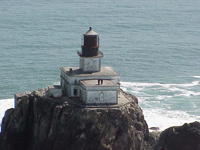
Tillamook Rock

You’ll notice this lighthouse as a rock that rises about a mile out to sea. Buffeted by sea and wind it seems to cling to the rocky surface. A lighthouse engineer first boated out to the rock in 1879 to determine if a lighthouse could stand there. Seemingly against all odds, the first surveyors accessed the site by jumping from a rocking boat onto the rock but it was hard to find local skilled workers for the construction after a mason was swept into the sea early on. Fighting the elements and a sixteen day storm that nearly took their lives they prevailed and the lighthouse, nicknamed “Terrible Tilly,” was lit for the first time on January 21, 1881. The worst storm in history nearly destroyed the lighthouse in 1934 and smashed the lens which was never re-lit. It was replaced by a red whistle buoy, anchored one mile seaward of the rock. In 1957 the last log entry was made and the lighthouse closed. It was sold to private bidders over the years and even became a columbarium where people could pay to have their human ashes left.This ghostly structure is listed on the National Register of Historic Places. Location: One mile west of Tillamook Head, can be seen from Ecola State Park

Cape Meares


This lighthouse sits 200 feet atop a cliff at the north end of the beautiful 20-mile Three Capes Scenic Loop along the Oregon coast.  The cape was originally called Cape Lookout by explorer Captain John Meares in 1788 but due to a nautical error the name was put on another cape 10 miles south so in 1857 it was renamed Cape Meares. The tower construction began in 1888. It is made of sheet iron lined with bricks and is the only one of its kind on the Oregon coast. The lighthouse was decommissioned in 1963 when an automated beacon was installed on a concrete blockhouse a few feet from the tower. The new light can be seen 25 miles at sea. There was talk of removing the lighthouse but local citizens rallied and funds were allocated to restore the lighthouse which was opened to the public on Memorial Day, 1980. Location: in Cape Meares State Scenic Viewpoint, about 10 miles west of Tillamook

Yaquina Head

Construction work began in the fall of 1871 but was often delayed due to the tempestuous Oregon winters. Finally, the light shone for the first time on August 20, 1873. Yaquina Head is the tallest tower on the Oregon coast, standing 93 feet tall. The light shines 162 feet above the ocean and can be seen nineteen miles out to sea. This lighthouse has always been popular with visitors and was considered one of the best maintained lighthouses on the West Coast. For many years it was closed to the public, then, in 1993 the Coast Guard turned it over to the Yaquina Head Outstanding Natural Area, managed by the Bureau of Land Management, and visitors were once again allowed to climb the 114 stairs to the tower.  It was restored in 2006 and is only open to the public during daylight hours. Location: one mile west of Agate Beach

Yaquina Bay

Standing on a hill overlooking the northern side of the entrance to Yaquina Bay, the lighthouse was built in 1871 to guide traffic into the bay. A couple years later it was decided it would be better to put a coastal light at Yaquina Head, four miles north. The house was empty for many years and then used as crew quarters for U.S. service personnel. In 1948, the Lincoln County Historical Society was formed with the purpose of saving the lighthouse but it wasn’t until 1956 that the lighthouse was finally dedicated as a historical site. Today it is on the National Register of Historic Places and part of the Oregon State Parks Department. In 1996 the light was re-lit and the Friends of Yaquina Lighthouses now assists in managing it and offers tours of the house,  which is furnished with period pieces. Location: Yaquina Bay State Park in Newport

Cleft of the Rock (Cape Perpetua)

Cape Perpetua was first discovered and named by Captain James Cook in 1778. The privately owned lighthouse was built in 1976 by former lighthouse keeper Jim Gibbs. Made from historic lighthouse pieces, it is a working official navigational aid. Location: at milepost 166 just off Highway 101, 1.8 miles south of Yachats. Not open to the public, but can be viewed from a pullout on the highway.

Heceta Head

Heceta Head

Named for a Spanish explorer who noted this area in 1775, Heceta Head Lighthouse stands high on a bluff, 150 feet above the sea, offering  spectacular views to all who visit, making it one of the most popular in the U. S. Construction of the lighthouse began in 1892. The 56 foot tower is the most powerful light along the Oregon coast and can be seen 21 miles out to sea – only stopped by the curvature of the earth.The state parks department maintains the lighthouse and today it is part of  Heceta Head Lighthouse State Scenic Viewpoint, which includes the park and cove. Currently the lighthouse is undergoing restoration and will remain closed for up to two years. Location: off Highway 101, twelve miles north of Florence, look for the road to Devils Elbow State Park

Umpqua River

An 1849 search for potential lighthouse locations along the Oregon/Washington coast produced a vote for a beacon marking the head of the Umpqua River. Where the river and ocean collided a hazard was created for ships docking to collect the precious lumber. Construction began in 1856 and though hampered by local Indians, who protested the building, the lens was lit in 1857. After years of  storms and floods the tower fell in 1864 and a replacement was not completed until 1894. This time the 65 foot tower was built further inland on a headland above the mouth of the river. This site is the furthest from a river or ocean of all lighthouses along the Oregon coast. Today the Fresnel light is still shining and is managed by Douglas County along with the Umpqua River Lighthouse Museum. Guided tours are offered March through December. Location: on a slope overlooking the entrance to the Umpqua River and surrounded by Umpqua Lighthouse State Park, six miles south of Reedsport

Cape Arago

Once home to the Coos Indians, Cape Arago now houses the third lighthouse to be built at that location  – the first, built in 1866 and the final one in 1934. Originally accessible only by boat, a cable tram was built in 1891 after several wooden bridges washed out over the years. Recently the land and lighthouse was transferred to the Confederated tribes of the Coos, Lower Umpqua and Siuslaw Indians with the stipulation that the lighthouse be available to the public for educational, park, recreational, cultural, or historic preservation. At the present, it can only be viewed from a distance. Location: south of Coos Bay, seen from Sunset Bay State Park
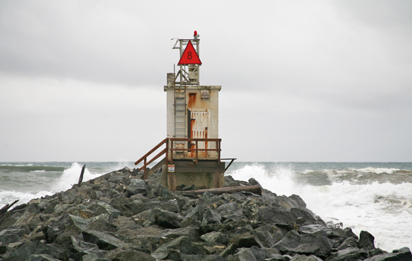
Coquille River

The Coquille River empties into the Pacific Ocean in the town of Bandon. The bar  formed by the interaction of river and ocean created an obstacle for ships so a jetty was created followed by the Coquille River Lighthouse in 1896 at the river’s mouth. The  top of Rackleff Rock was leveled for the base and local stone was cut to form the foundation. The fire of

Coquille River Lighthouse

1936 consumed most of the towns 500 buildings but the lighthouse was spared. In 1939 an automated beacon was installed at the end of the south jetty and the lighthouse was abandoned for twenty-four years until Bullards Beach State Park was created and the park assumed responsibility for the lighthouse. After its restoration, the lighthouse was opened to the public with tours. Location: look for the entrance to Bullards Beach State Park just north of Bandon before you cross the Coquille River Bridge.
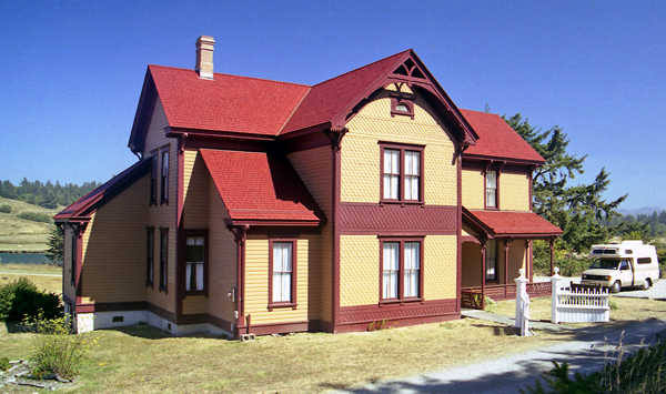
Cape Blanco

Spanish explorers named this landmark after the chalky “White Cape.” The land was cleared of trees and the lighthouse completed in 1869 – standing 200 feet atop a cliff that juts out along the coastline.  Later, a ranch was built which is now Cape Blanco State Park, and the home, a two-story Victorian built in 1898 (listed on the National Register of Historic Places) is open to the public for tours. The lighthouse was restored in 2003. Visitors are allowed to ascend the spiral staircase to the lantern room. Location: four miles north of Port Orford, six miles off Highway 101, look for the sign between milepost 296 and 297

Pelican Bay

This privately built and owned lighthouse was approved by the federal government and first lit in 1999. The newest lighthouse in the U.S., it is perched on the corner of a 100 foot cliff. Location: above the port of Brookings Harbor

For complete history, ghost stories and more check out the complete articles at:

http://www.lighthousefriends.com/pull-state.asp?state=OR

http://www.nwcoast.com/lighthouses/oregon.asp

Pelican Bay pic courtesy of Bruce & Suzanne Watkins

Cleft of Rock pic and other links courtesy of Lighthouse Friends

Bandon by the Sea

This slideshow requires JavaScript.

My 81-year-old mother and I headed to Bandon on the southern Oregon coast for the weekend to help her brother celebrate his 80th Birthday.  Bandon’s a place I’d been to quite a bit over my life because of the relatives that lived there since I was a child. It’s only recently I discovered how wonderful Bandon truly is.  In fact, it’s so nice that in 2010 Budget Travel named it one of the “Coolest Small Towns in America.” That’s saying something considering the town was wiped off the map by a devastating fire in 1936 where people survived only by seeking refuge on the dock, beach and in the surf.

Today Bandon’s back and booming. And to prove it, here’s a sampling of what I like about it:

First off, it was settled by Irish man George Bennett (my last name’s O’Leary). The weather can be unpredictable and never boring (also like me). And for years they’ve made Bandon Cheese here.

Rock formations along the craggy coast create interesting view points and the scenic beauty will be sure to offer many photo ops. I love to drive the Beach Loop that winds along the cliff where many stops lead to paths or stairways dropping down to the pristine sandy beaches below.

The rocks have names like Face Rock, Garden of the Gods, Table Rock, Cat and Kittens Rock and Elephant Rock.  Local legend says Face Rock’s of an Indian maiden that was frozen into stone by an evil spirit. The Cat and Kittens Rock are her animals that were thrown into the sea and turned to stone by the same nemesis.

Another favorite locale is the Coquille River (named after the local native Indians). The river runs along the South side of Bandon where it empties into the Pacific along a rock jetty. The area is buffeted by crashing waves and has a history of ship wrecks the locals love to retell. Nearby, the Coquille River Lighthouse stands proudly and offers tours.

Old Town offers quaint shops, great restaurants, and a boardwalk with interesting wood animal sculptures and other art. There’s a pier, port, dock, boat ramp and marina – great for fishing and sight seeing.

Cranberries are a popular product of Bandon and there’s a a Cranberry Festival in September to celebrate the harvest.  My uncle’s family has grown cranberries here for years and they owns bogs on a farm just out of town.

Other highlights include: four world premier golf courses including Bandon Dunes Golf Resort, you can explore nearby Bullards Beach State Park, Bandon Marsh and Oregon Islands National Wildlife Refuges, Bandon Historical Society Museum, West Coast Game Park Safari, plus the Oregon dunes are just a hop skip and jump away.

Of course there’s all the other charms and activities of a beach town like surfing, crabbing, etc, but one thing’s for sure – if you visitBandon you’ll want to return again and again.

Grants Pass

On a recent trip to Sequoia National Park I got off the I-5 and made a stop in Grants Pass to visit some friends. It had been many years since I had been there and my only recollections were of the 40-mile backpacking trek I had taken with two girlfriends on the Rogue River Trail in the early 70s. I know we had stopped in the town to get supplies and see the last of civilization for the next two weeks but the details escaped me. Things change anyway, so I’m sure very little of it would appear the same.


Grants Pass had its beginnings in the 1880s with the introduction of the railways and became a bustling frontier town. It really began to thrive when gold was discovered. Then the timber industry took hold, farming and today tourism.

Its main claim to fame has always been the Rogue River and the back drop of mountains, ancient forests and surrounding valleys plus great climate.  It has drawn everyone from the early Hudson Bay hunters and trappers to world-wide celebrities. Movies have been made here.

River attractions include: jet boat tours, rafting, fishing, hiking and wildlife viewing.  Other favorite pastimes:  wine tours, a visit to the historic part of town which has been designated a National Historic District, and yearly festivals including a Native American Pow Wow.

From Grants Pass I took the scenic drive along Highway 199 to Cave Junction where I spent the night with friends. I had to leave early the next morning but managed to enjoy some of the beauty of this part of Oregon. Someday I want to visit the Oregon Caves National Monument. For me, at this time,  Grants pass was a pit stop on a larger journey.

I visit places frequently and think how much I would like to come back and really explore every nook and cranny. Grants Pass and Cave Junction were two such places.

Astoria to Ecola State Park ~ Oregon Coast

This slideshow requires JavaScript.

My 28-year-old son had lived in Oregon for three years and never ventured to the Oregon Coast. Well, not since he was a year old. I’m a born and raised Oregonian but when I graduated from high school I left to travel and didn’t return until many years later when my son was a year old. We lived in Portland for four years and then I left for Los Angeles to finish college and didn’t return for more than 20 years. The Oregon I came home to had changed – I loved it even more.

Some of my friends that have stayed here all that time are a little more skeptical about Oregon’s changes, if they’re for the good. But I’m seeing it all with new eyes. Plus, I’ve been a lot of places. Seen a lot of things – good and bad.

I soon discovered my new found love of Oregon was so powerful I had to express it, share it, promote it – thus this blog and a Facebook travel page called Go Oregon Now and a Twitter account where I follow and tweet only about Oregon. I like to say, “I have my fingers on the pulse of Oregon.”

A few weekends ago I convinced my son and my mom to visit the Oregon Coast. We headed to Astoria because there were a couple of waterfalls along the way and my son loves waterfalls. That was the motivation, the carrot I dangled, to get him to go. I don’t think he knew he would love it so much, but he did.

I hope you enjoy the slide show of our journey.  We went from sun in Astoria to fog in Seaside.  But I think you’ll agree each carries it’s own special charm. There’s so much to see and experience along the coast when you travel in Oregon.

A Day in Oregon City

Looking toward Oregon City under I-205, in distance - historic bridge and Willamette Falls

Since relocating back to Oregon three years ago I have met some very interesting and fun people. One friend, Ginnie, and I get together every Tuesday (that we can) and see something new in the Portland area, where we both live.  This week we ventured further south to Oregon City. This was an area where I grew up so it holds a lot of memories for me. I moved here when I was in fourth grade and left in the ninth when my family decided to move to Oak Grove.

Oregon City has maintained its historical flavor over the years and this was one of the things I liked about it. Lately they’ve been sprucing up the neighborhood ( as many cities have been doing) and hanging flower baskets adorned many of the lamp posts. You’ll find historical buildings and homes all over the place and there’s a walk-about of Oregon City that’s fun and interesting, if you like that kind of activity check with the visitor center or me. Plus, the Clackamas County Historical Society Museum has its home here.

Courthouse adornment

Building across from the courthouse

Elevator connects two levels of Oregon City

Visiting Oregon City brought to mind the Oregon Trail and pioneer days – after all, it was the first city to incorporate west of the Mississippi. It was home to fur traders and missionaries and soon became known as “the end of the Oregon trail.” Later the paper mills sprang up as well as houses along the river, populated by employees of the Hudson Bay Company.

Ginnie and I took the elevator (it even had an operator) to the top of Singer Hill. There’s also a road along the cliff (if you want to drive) that was once a Native American path that expanded over the years to its present state. For a little more exercise – turn left at the base of the elevator (be sure and notice the 3-D historic photos lining the walls) and follow a tunnel to an old rock stairway that winds to the top past Singer Creek Falls .  A fountain stair-steps down the lower part of the hill to the railroad tracks at the base. Another tunnel takes you under Singer Hill Road and you’ll end up in the yard of two historical homes – the John McLoughlin Home (city founder) and Barclay Home (man prominent in community affairs) both can be toured.

Nearby church

The McGloughlin House

Barclay House


The top of the hill had a completely different atmosphere than the bottom. McLoughlin Promenade, a 1930s parkway along the top of the hill was recently renovated and offered different vantage points along the cliff where we viewed the city below, the Willamette River and Willamette Falls.  I frequented this area as a kid and a lot of it still looked the same.  Further up the hill a few buildings had been demolished (sadly the old theater) and others had been rennovated and turned into something new.  I entered the library and it was exactly as I remembered it. Same with the park and playground. Here are a few sites I remembered from my childhood:

Firehouse

Playground

Library


Singer Hill Cafe  has been mentioned as a popular spot to grab a bite to eat so Ginnie and I decided to try it. The food was not great the day we ate there but the atmosphere made up for it. There’s an art gallery inside and an outdoor patio with plants growing on the walls and even covering the outside of the garbage can. It’s a “must see” when you’re in the neighborhood. The plant design is the work of the Oregon City Vertical Garden Institute.

Lunch salad

Singer Hill Cafe

Outside dining


Be sure and visit the Willamette River Walkway and John Storm Park plus the Willamette Falls Viewpoint off Highway 99E on the way up toward Canby above the old paper mills. This is only a smidgeon of what historic Oregon City can offer but it’s a good start.                     Happy exploring…

Kayaking on the Willamette

Kayaking on the Willamette

Ducks at John Storm Park

Willamette Falls from Viewpoint

Manzanita – Northern Oregon Coast

The quaint village of Manzanita “little apple” is located in Tillamook County just two hours from Portland along the North Coast and offers visitors seven miles of pristine beach. An undisturbed beach community, unique gift shops and a thriving art venue help make Manzanita appealing to those who want a delightful getaway. You’ll find outstanding restaurants, vacation rentals and nice hotels to make your stay comfortable.

High above, on Oregon Coast cliffs, highway 101 turns out at the Neah-Kah-Nie Mountain Wayside. The broad sand of Manzanita Beach reaches into the sea. The Nehalem Bay Jetty lies south, enshrouded in morning fog. 

Popular locations abound for exploring, hiking, camping,  beach combing, fishing, crabbing, horseback riding, bicycling, boating, river kayaking, surfing, seal watching, kite flying, and wind surfing.

Build a sandcastle or study a tide pool but be sure to stay for a colorful sunset.

Visit nearby Oswald West State Park for beach exploration or Nehalem Bay State Park known for its forest hiking and exquisite vistas. Also close are Arcadia Beach and Hug Point.

Nehalem

If you’re staying for a few days and feel like venturing out, the little towns of Nehalem (on the Nahalem River) and Wheeler (overlooking Nehalem Bay) are inland on 101 not far away to the south.

Wheeler looking back at Manzanita

Hawthorne District & Laurelhurst Park

People have been adding text to the stop signs in Portland

Spent a day with my photographer friend Tom who lives in SE Portland. It was his Birthday and we were originally planning to go to The Japanese Gardens but time got away with us and we decided to have lunch and explore the area and take pictures. It took us a while to pick the right restaurant but decided on Bread and Ink Cafe in the Hawthorne District. Liked the food and the atmosphere plus everyone’s friendly. I got a BBQ sandwich and Tom got their hamburger. Good fries and salad too.

After lunch, walking back to the car, I noticed a couple yards that had added creative touches. It’s fun driving or walking around Portland just to look at yards sometimes.

Mosaic wall with antique door knobs

Ceiling light globes all in a row


Next we decided to head over to Laurelhurst Park.  It’s a huge park – had paved paths with multiple levels located over by 39th and Stark. The land was originally part of an estate purchased in 1909. It eventually became named the most beautiful park on the west coast by the Pacific Coast Parks Association.

The place was obviously a favorite hang out with people strolling, jogging, skateboarding, reading, watching the ducks on the pond, throwing Frisbee, playing with children.  I was taking pictures and marveling at the multitude of things available to do here. There’s many play areas.

Sculpture and walking paths

The park’s beautifully landscaped with exotic plants (many labeled) plus there were several ponds of an emerald color filled with ducks, fish and frogs.

Enjoying the pond


One of my passions is macro photography and I especially like to capture the unique beauty that each flower possesses. When a photo is enlarged there are parts of the flower not visible to the naked eye that suddenly appear as if by magic. There’s a wonderland in most flowers that goes unobserved except on the most superficial level.

After leaving the park we enjoyed the neighborhood. I noticed many people plant vegetable gardens in their front yards mixed in with shrubs and flowers. I do the same thing and like this trend toward urban farming. It makes sense and tastes good too.

A few of the houses I liked

Happy Birthday Tom. Had a great time together today.

Hiking Eagle Creek

This slideshow requires JavaScript.


When I was in high school I belonged to a survival club and we learned how to live in the wilds – always a fascination for me. I learned a lot about Oregon during those years and my love for this part of the country became a foundation for the rest of my life.

One place our little survival group backpacked was Eagle Creek in the Columbia Gorge. Back then it wasn’t such a popular hot spot as it is now and hiking Oregon’s many trails were not as congested. There was an unspoken code that hikers followed, almost like a religion. It was sacred. Just as sacred as the land we trod. I think that code could be summed up in one word – reverence. But with that came respect and responsibility. I’ll call it the 3 R’s. True outdoor lovers left nature as they found it – or better.

My son and I had been hiking the Gorge every week and this week he chose Eagle Creek. He had never hiked there before and the three nice waterfalls along the shortened version of the hike made it appealing. We both love waterfalls – so much, that we’ll bushwhack cross country to find one we’ve heard about Online. Always respecting nature’s delicate balance and vegetation.

Today, Eagle Creek’s a popular summer hike and this particular weekend the kids were having one last fling before school started. The creek offered some nice swimming holes and cliffs to jump from and it was a hot day in the high 80s – maybe even 90s.

I enjoyed the people on the trail. I know many hikers seek solitude and avoid a busy locale and though I don’t usually want a crowd, I don’t mind a handful of people. This day I would have to say it was a crowd. Almost a party atmosphere at Punch Bowl Falls. But I joined in and my son and I had fun.

At one point, I was lying on my stomach on the rocks beside the creek to get a low angle shot of Punch Bowl Falls. All of a sudden a yellow tennis ball lands in the water about two feet from my head, splashing water on me and my camera. In the next instant a brown Lab leapt into the creek after the ball splashing me even more. I had just barely moved my camera away from the water and sat up only to have the dog shake the water from his fur (right beside me) happily holding the ball in his mouth. “Sorry,” I hear a female voice meekly utter.

What ya gonna do? Would have been funny if it hadn’t been me. I’m laughing now.

But its good to see this love of our natural wilderness. I think lately many of us have felt we’re taking Survival 101 (those who have fallen on hard times) just trying to get along the best we can plus have a little fun mixed in there to make the going easier. The outdoors beckons us during these times and can offer relatively inexpensive entertainment.

I believe getting back to our roots is the best way to reconnect with who we are and what were capable of accomplishing. It’s sacred ground. The wilderness is our home and hopefully together we can all work to keep it the way we love it now so future generations can tread the same paths we’ve walked and find whatever it is we all seek when we head out to a forested path.

Latourell Falls Loop Hike – The Gorge

This slideshow requires JavaScript.


My son Ryan and I headed out to the Columbia Gorge early. It was a Saturday and we knew it would be crowded as the day wore on. Our hikes had all been on weekdays but the Gorge seemed crowded even then.

The Latourell Falls loop trail was only 2.4 miles but got steep at places, rocky and rutted. There’s several precipices along the way so if hikers feel compelled to wander out to the edge to look over, be forewarned it’s a vertical drop of about 600 feet. The top of the falls was visible without venturing to the end.

We saw a guy with his dog carelessly getting close to the edge (the oblivious puppy had his front toes hanging half off the tufty ledge). I sort of warned the guy and he grudging told me he had lived here for 20 years. I simply wanted him to have at least another 20.

We began the hike east of the falls where the trailhead was clearly marked. The first leg of the journey involved a steep trek but the reward was a view of Latourell Falls through the trees and foliage. The trail followed the creek which was full of its share of cascading water creating a musical sound, accompanied by the various birds that call this home.

After a while we reached Upper Latourell Falls. It gushed over the canyon wall dropping 120 feet and began its cascade down the hill. A wooden bridge crossed the creek at the base of the falls and a more adventurous person could gingerly navigate the slippery rocks to get somewhat behind the falls.

There was a family with six children and four of the boys eagerly did just that. They were wearing tennis shoes and hopping around barely staying upright, taking risks to get out close to the falls. Ahh youth. And, yes, that would have been me at that age. The mother called warnings but they heeded them not.

From here the trail traveled through dense foliage to an overlook, then headed uphill for a short way before making a sharp turn and heading down the hill to the scenic highway.

Be sure and cross the highway and walk through Guy W. Talbot State Park. There’s picnic tables and grills, so a good place to have lunch. We ate here by the woods. There was also a clean restroom.

From here, we headed toward the creek to the east and picked up the trail again. It followed high above a canyon. Be sure and look back after crossing under the highway for an impressive view of the bridge.

Now the trail took us to the base of Latourell Falls – a mouth-gaping wonder. By this time, the crowds had gathered and many were lined up simply staring at the 249 foot falls (one of my favorites along the Gorge) with mossy basalt cliffs that appeared to be a work of art.

Children loved to play in the creek by the bridge and hikers waded near the falls to be misted. My son proclaimed it was like a spiritual experience and he felt almost euphoric. He kept enthusiastically mentioning it so I figured something must have happened, he not an effusive guy. It must have been all that oxygenated air created from the negative ions.

We did venture over the water-slicked rocks to get behind the falls. There’s a trail but, again, caution is called for because the rocks are unforgiving with pointed tips if ever a person should fall. Ouch!

If you want some serenity go early in the morning because by the time we left at 1 PM the traffic was jammed and lined up a ways down the scenic highway. Luckily we were headed the opposite direction.

When visiting the Gorge, driving along to enjoy the roadside waterfalls is lovely, to be sure, but venture further in on the multitude of trails – the rewards and wonderment are limitless. Take a hike!

Multnomah Falls – Wahkeena Loop Trail

This slideshow requires JavaScript.

This Columbia Gorge hike is sometimes called the waterfall hike because there’s so many falls along the trail. Several major creeks travel down through the Gorge to become Multnomah Falls, Wahkeena Falls and inner Fairy Falls. Along these creeks other waterfalls drop at various places and can be seen along the path. Most of these falls have unmarked side-trails for the more adventurous (like my son) and because I tag along, I find myself at the bottom of each of these falls – totally immersed in nature – it’s exhilarating.

After a while we leave Multnomah Creek and travel high above the Gorge over to Wahkeena Springs. This part of the trail cuts across a steep tree-lined slope. It’s a world everyone should enter at some time in their life. For me, it brings a respect for life. Everything around me creates this visible ecosystem that hangs in a balance supporting each living thing. It’s one definition of beauty.

Into the Wilds


We have our picnic lunch near Wahkeena Springs. It bubbles from the ground and soon spreads and picks up speed as it tumbles over rocks down the hill. Before long it’s raging, twisting, turning, falling and the trail follows it down to the scenic highway and the Wahkeena Falls we all know and love.

We hike nearly seven miles today. I can feel it in my joints and in my feet. We end at Multnomah Falls (where we began) and have our favorite ice cream cone.

On a final note, I’m sad that so many people have to litter and pollute our natural environment – water bottles, wrappers, toilet paper in visible areas, the remains of their lunch. Respect for the land and this home of creatures was taught to me somewhere along the way. Or maybe it was common sense. But I wish people would carry out their garbage. I told my son I’m bringing a garbage bag on our next trip so I can leave it cleaner than I found it. Leave no trace.

Top of Multnomah Falls

Previous Older Entries